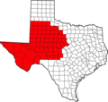
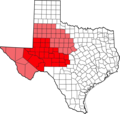
Category:West Texas
Jump to navigation
Jump to search
region in Texas, United States | |||||
| Upload media | |||||
| Instance of | |||||
|---|---|---|---|---|---|
| Location | Texas | ||||
| Different from | |||||
| |||||
Subcategories
This category has the following 17 subcategories, out of 17 total.
*
- Amherst, Texas (1 F)
- Fluvanna, Texas (5 F)
- Salt Flat, Texas (14 F)
- Sudan, Texas (3 F)
C
- Crash at Crush (13 F)
I
W
- Wilson, Texas (3 F)
Media in category "West Texas"
The following 125 files are in this category, out of 125 total.
-
Delaware Basin map.PNG 1,160 × 734; 123 KB
-
110426-F-RM405-451 (5662097746).jpg 4,256 × 2,832; 922 KB
-
Acuff Steakhouse Texas 2010.JPG 4,080 × 2,720; 4.09 MB
-
Rc791.jpg 800 × 592; 64 KB
-
Anton Texas Boothe Elevators and Rail 2010.jpg 3,072 × 2,048; 2.36 MB
-
Barbedwire3.jpg 1,200 × 900; 267 KB
-
Blanco Canyon 2009.jpg 3,071 × 1,577; 2.6 MB
-
Blanco Canyon in Crosby County Texas 2009.jpg 3,050 × 2,014; 3.96 MB
-
Blanco Canyon White River Texas 2009.jpg 3,072 × 2,048; 2.88 MB
-
BlancoCanyon 2005.jpg 1,280 × 960; 640 KB
-
Borden County High School Gail Texas 2010.jpg 3,888 × 2,592; 2.47 MB
-
Borden County Texas Courthouse 2010.jpg 4,000 × 3,000; 4.28 MB
-
Breckenridge Texas Mural.JPG 3,008 × 2,000; 2.85 MB
-
Breckenridge, Texas Mural.JPG 3,008 × 1,615; 2.52 MB
-
Buenos Texas BNSF Railway 2011.jpg 5,616 × 3,353; 5.39 MB
-
Bula Cotton Gin, Bailey County, Texas, 2011.jpg 4,080 × 2,720; 4.86 MB
-
Burch Hotel.JPG 1,818 × 2,490; 1.66 MB
-
Caprock Escarpment Garza County Texas 2010.jpg 3,072 × 2,048; 2.88 MB
-
CentraliaDraw 2004.jpg 2,048 × 1,360; 1.47 MB
-
Close City Texas abandoned school.jpg 3,840 × 2,688; 6.51 MB
-
Cocklebur Seedling West Texas 2003.jpg 1,974 × 1,680; 2.92 MB
-
Cone Texas School 2010.jpg 4,080 × 2,720; 4.15 MB
-
Contrabando Church.jpg 640 × 480; 75 KB
-
Cotton Center Texas water tower 2010.jpg 1,988 × 3,042; 3.34 MB
-
Double Mountain Stonewall County Texas 2009.jpg 3,984 × 2,321; 3.41 MB
-
Duffy's Peak Garza County Texas.jpg 5,616 × 3,744; 6.04 MB
-
Earth Texas Plant X 2008.jpg 2,816 × 1,464; 1.88 MB
-
Estacado Texas Church 2011.jpg 5,616 × 3,744; 4.41 MB
-
Estacado Texas historical marker 2011.jpg 5,414 × 3,609; 5.24 MB
-
Face. Horse head on pumpjack. - Flickr - Night Photo.jpg 3,238 × 1,821; 1.4 MB
-
Far West Texas is known for its vast amount of diversity. (24486734793).jpg 4,256 × 2,832; 2.42 MB
-
Farm in west texas Nima.JPG 3,108 × 2,448; 2.21 MB
-
FM669 Garza County Texas 2010.jpg 3,072 × 2,048; 3.54 MB
-
Gail Mountain Borden County Texas 2011.jpg 5,616 × 3,744; 4.99 MB
-
Gail Mountain Borden County Texas.jpg 3,072 × 1,500; 1.81 MB
-
Girard Kent County Texas 2015.jpg 4,693 × 2,649; 4.49 MB
-
Haboob Ransom Canyon Texas 2009.jpg 4,000 × 2,334; 1.65 MB
-
Hill 1899 VanHornMts.jpg 4,432 × 2,824; 7.04 MB
-
Ira Texas Sterling Grocery & Hardware.jpg 5,616 × 3,000; 5.94 MB
-
Jeffk - West Texas Lightning Storm (by).jpg 3,456 × 2,304; 2.2 MB
-
Kalgary Texas Cotton Gin 2011.jpg 5,508 × 2,835; 4.36 MB
-
Kokernot Field Rock Wall 2010.jpg 4,080 × 2,720; 7.88 MB
-
Lamb County Texas Windmill 2011.jpg 5,417 × 2,824; 6.3 MB
-
Levelland Texas grain elevator 2011.jpg 5,616 × 3,744; 6.35 MB
-
Llano Estacado Caprock Escarpment south of Ralls TX 2009.jpg 2,816 × 1,880; 3.36 MB
-
Lubbock County South Plains Fair 2010.jpg 2,048 × 3,072; 2.77 MB
-
Lubbock County South Plains Fair 2012.jpg 5,431 × 3,621; 8.85 MB
-
Lubbock County Texas wind turbines 2011.jpg 5,616 × 3,744; 5.15 MB
-
Mesquite School Borden County Texas 2010.jpg 3,888 × 2,592; 2.47 MB
-
Mountains fill the horizon over this water storage facility in West Texas. (24486247243).jpg 4,256 × 2,832; 2.19 MB
-
Mountains fill the horizon over this water storage facility in West Texas. (24817470330).jpg 4,256 × 2,832; 3.39 MB
-
Mt Blanco 2005.jpg 3,072 × 2,048; 2.53 MB
-
Mushaway Peak Borden County Texas 2010.jpg 3,072 × 2,048; 2.24 MB
-
Nazareth Texas City Hall 2009.jpg 3,121 × 2,050; 3.93 MB
-
Needmore Co-Op Gin, Bailey County, Texas.jpg 3,456 × 1,884; 3.87 MB
-
New Deal Texas Cotton Gin 2010.jpg 3,027 × 2,022; 3.39 MB
-
New Home Texas Water Towers 2011.jpg 5,616 × 3,744; 3.43 MB
-
New Mexico and West Texas (MODIS 2020-05-02).jpg 3,000 × 2,205; 651 KB
-
Notrees Texas Road Sign 2009.JPG 3,984 × 2,656; 2.16 MB
-
OdessaPermian-pagebanner.jpg 960 × 137; 27 KB
-
OdessaPermian.jpg 960 × 540; 42 KB
-
Palo Duro Canyon 2002.jpg 1,536 × 1,024; 1.07 MB
-
Palo Duro Canyon State Park 2002.jpg 1,280 × 960; 270 KB
-
Patricia Texas sign 2009.jpg 3,596 × 1,780; 2.77 MB
-
Pep Texas Post Office 2010.jpg 2,095 × 1,322; 804 KB
-
Petersburg Texas Grain Elevator 2010.jpg 3,072 × 1,983; 2.51 MB
-
Petersburg Texas Grain Elevator 2010b.jpg 3,429 × 2,328; 2.7 MB
-
Petersburg Texas Sign 2010.jpg 3,030 × 1,980; 2.21 MB
-
Plains Community Center Borden County Texas 2011.jpg 3,964 × 1,772; 2.64 MB
-
Prairie Dog Town Fork Red River 2001.jpg 638 × 801; 352 KB
-
Ralls Texas Grain Silos 2010.jpg 2,816 × 1,506; 2.24 MB
-
Ransom Canyon Water Tower 2009.jpg 2,656 × 3,984; 4.33 MB
-
Rath City Texas 2009.JPG 3,888 × 2,592; 2.29 MB
-
Reese Air Force Base Lubbock Texas 2010.jpg 5,616 × 3,744; 3.4 MB
-
Rhea, Parmer County, Texas, grain elevator, 2010.jpg 3,904 × 2,720; 2.29 MB
-
Richardson 1908 FranklinMts.jpg 4,344 × 3,149; 7.17 MB
-
Rio Grande EP Upper Valley.jpg 2,560 × 1,920; 1.44 MB
-
Ropesville Texas grain elevator 2011.jpg 5,616 × 3,744; 5.04 MB
-
Greetings from Roscoe, TX.jpg 367 × 260; 145 KB
-
Roscoe Texas grain elevator 2011.jpg 4,080 × 2,720; 3.12 MB
-
Salt Fork Brazos Kent County Texas 2015.jpg 5,616 × 3,744; 5.37 MB
-
Salt Fork Brazos River FM651 Texas.jpg 3,984 × 2,656; 5.59 MB
-
Sierra Blanca Mountain.jpg 5,184 × 3,456; 7.45 MB
-
Sierra Blanca TX.jpg 856 × 570; 533 KB
-
Smyer Texas Water Tower 2011.JPG 4,080 × 2,720; 3.27 MB
-
Solar pumps offer an alternative to windmills in West Texas. (25019610611).jpg 4,256 × 2,832; 7.03 MB
-
Southland Abandoned Farmhouse 2009.jpg 2,816 × 1,578; 2.44 MB
-
Southland BNSF tracks 2009.jpg 3,072 × 2,048; 3.87 MB
-
Spade Ranch Hockley County Texas 2011.jpg 5,255 × 3,012; 4.48 MB
-
Spade Texas School 2011.jpg 3,072 × 2,048; 3.73 MB
-
Stiles Texas 2004.jpg 2,048 × 1,360; 1.26 MB
-
Sun going down on cropland field in West Texas. (24818645380).jpg 4,195 × 2,792; 3.52 MB
-
Texas Hwy 207 Crosby County 2009.jpg 2,816 × 2,112; 2.23 MB
-
The open skies of Texas - Flickr - illusionbreak.jpg 2,048 × 1,152; 786 KB
-
Thirsty plants wait for the rains in West Texas. (24995317582).jpg 4,256 × 2,832; 3.47 MB
-
Threemile Mt 2008.jpg 3,055 × 1,642; 2.47 MB
-
Tx Hwy 207.jpg 960 × 1,280; 599 KB
-
US Highway 82 Lubbock County Texas 2011.jpg 5,616 × 3,744; 6.48 MB
-
VanHornTX 2008.jpg 3,072 × 2,048; 2.85 MB
-
Wastella Texas grain elevator 2011.jpg 5,420 × 3,744; 3.58 MB
-
Waving to the Sky.jpg 1,880 × 2,816; 2.69 MB
-
Wayside, Lynn County, Texas, Abandoned shack.jpg 5,416 × 2,995; 5.26 MB
-
West Texas County Map.png 2,560 × 2,433; 689 KB
-
West Texas Hwy 302 west of NoTrees.jpg 2,048 × 1,360; 1.23 MB
-
West Texas Indian Tribes -- 1600.jpg 654 × 536; 25 KB
-
West Texas Indian Tribes1 -- 1600.jpg 621 × 536; 25 KB
-
West Texas Lightning Storm.jpg 3,456 × 2,304; 2.05 MB
-
West Texas Pumpjack.JPG 2,576 × 1,932; 417 KB
-
West Texas rangeland shares space with wind turbines. (24745989359).jpg 4,256 × 2,832; 2.5 MB
-
West Texas Regional Map.png 2,560 × 2,433; 692 KB
-
West Texas Road.JPG 3,072 × 2,304; 3.52 MB
-
West Texas Scenery.JPG 2,592 × 1,944; 657 KB
-
West Texas Sunrise.jpg 310 × 232; 22 KB
-
White River Silver Falls Texas 1891.jpg 1,816 × 1,064; 801 KB
-
White River Silver Falls Texas 2008.jpg 3,072 × 1,851; 1.49 MB
-
Whiteface Texas Museum 2011.jpg 4,724 × 3,100; 3.39 MB
-
Whitharral Texas Cotton Gin 2010.jpg 3,456 × 2,304; 4.31 MB
-
Whitharral Texas Panthers six-man football 2010.jpg 3,072 × 2,048; 2.09 MB
-
Whitharral Texas Water Tower 2010.jpg 2,792 × 1,794; 1.7 MB
-
Yardang Lea-Yoakum Dunes.jpg 601 × 391; 33 KB
-
Yellow House Canyon north of Slaton Texas 2009.jpg 3,072 × 2,048; 3.94 MB
-
Yellow House Canyon northeast of Slaton Texas 2009.jpg 3,072 × 2,048; 2.46 MB
-
Yellow House Draw Head 2009.jpg 3,047 × 2,004; 3.47 MB


.jpg/120px-110426-F-RM405-451_(5662097746).jpg)


_(14763066102).jpg/120px-Annual_report_of_the_United_States_Geological_Survey_to_the_Secretary_of_the_Interior_(1899)_(14763066102).jpg)


.jpg/120px-Far_West_Texas_is_known_for_its_vast_amount_of_diversity._(24486734793).jpg)


.jpg/120px-Jeffk_-_West_Texas_Lightning_Storm_(by).jpg)


.jpg/120px-Mountains_fill_the_horizon_over_this_water_storage_facility_in_West_Texas._(24486247243).jpg)
.jpg/120px-Mountains_fill_the_horizon_over_this_water_storage_facility_in_West_Texas._(24817470330).jpg)


.jpg/120px-New_Mexico_and_West_Texas_(MODIS_2020-05-02).jpg)


%2C_by_J.D._Smillie%2C_published_1857.jpg/120px-Rio_San_Pedro—Above_Second_Crossing_(Devil%27s_River%2C_Texas)%2C_by_J.D._Smillie%2C_published_1857.jpg)


.jpg/120px-Solar_pumps_offer_an_alternative_to_windmills_in_West_Texas._(25019610611).jpg)


.jpg/120px-Sun_going_down_on_cropland_field_in_West_Texas._(24818645380).jpg)


.jpg/120px-Thirsty_plants_wait_for_the_rains_in_West_Texas._(24995317582).jpg)


.jpg/120px-West_Texas_rangeland_shares_space_with_wind_turbines._(24745989359).jpg)


